

Oldham Weather Forecast: Storm Goretti Brings Snow Risk Before Milder Conditions Return (8th–11th January 2026)
The new Oldham Weather forecast starts with one of the biggest weather events of the season to date as Storm Goretti is heading towards the UK. Following a below-average start to January so far with unsettled weather and below-average temperatures in some parts of northwest England, the focus is now on a developing area of low pressure that may bring more disruptive weather. Each location may receive only rain, but others, especially over higher terrain, may receive sleet or snow accumulations prior to a gradual decrease in cold temperatures over the weekend. The start of January has been a true winter one and has seen a number of snowfall events and icy mornings, to name just a few, throughout the region, with widespread frosts. While not all areas got enough snow for the first week of the month, many higher elevations saw snowfall, and in lower elevations, it was often rain or only temporary snowfall. Now with the arrival of Storm Goretti, there is added uncertainty as slight variations in the track of the storm could have a significant impact on the snowfall areas and the intensity of the conditions. The path of the low-pressure system will continue to be tracked closely as this will decide whether Oldham stays on the colder side of the system or whether slightly milder air heads inland. Rainfall can also cause evaporative cooling, which can reduce the temperature and cause precipitation that would otherwise be rain to become snow even in areas where the initial temperature is not considered to be low enough. This means forecasts may continue to change as the storm approaches. On the other hand, following Storm Goretti, there will be a more subdued, yet cold, weather pattern. Temperatures should gradually improve early next week, but extended forecasts suggest that colder continental air may be moving back in late January. However, for the time being, the primary concern is the near-term effects from Storm Goretti and the potential for additional snow before the weather slowly settles into less harsh conditions.
Oldham Weather Forecast Highlights
|
Day |
Weather |
Maximum |
Minimum |
Wind Gusts |
|---|---|---|---|---|
|
Thursday |
Rain, sleet or snow with strengthening winds |
5°C |
0°C |
25 mph |
|
Friday |
Cold with bright spells and wintry showers |
4°C |
-1°C |
25 mph |
|
Saturday |
Cold with sunny spells |
4°C |
-2°C |
15 mph |
|
Sunday |
Bright start, cloud increasing later |
4°C |
1°C |
20 mph |
Thursday Oldham Weather Forecast
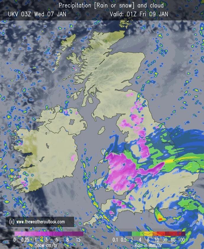
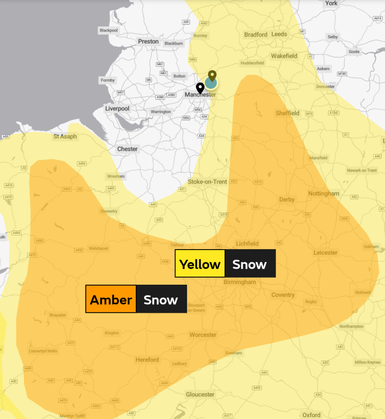
The first part of Thursday will be cloudy and misty with occasional light wintry showers. Winds remain relatively light during the early stages, and a few stronger periods could occur around lunchtime, before the poor weather arrives during the afternoon. By the evening, the northeasterly winds are enhanced as Storm Goretti is moving into the region from the south; therefore, thicker cloud and a higher probability of rain spreading over the area. The type of precipitation (rain, sleet or snow) will be influenced by local temperatures and the severity of the precipitation. Sleet/snow is more likely in the lower-lying western parts of the area, whilst the Pennines, Peak District and inland districts have a higher risk of sleet/snow, especially in heavier precipitation. There may be travel disruptions, particularly on higher routes, and forecasts can continue to change as the exact path of the storm becomes more certain. Cloud will increase in amount throughout the afternoon, and as the afternoon gets underway, it will become quite cold with the wind increasing. Heavier precipitation will arrive during evening hours, which may lead to changing conditions, especially in exposed and elevated areas. Sleet and wet surfaces may be hazardous even if there is no snow, if temperatures approach the freezing point. Heavy bursts can also reduce visibility, making journeys more challenging. Thursday evening may be especially miserable as strong winds and wintry conditions are anticipated, so motorists should stay up to date on the latest weather reports from their local area.
Friday Oldham Weather Forecast
Storm Goretti will have exited into the North Sea by Friday morning, with precipitation gradually easing from West to East. If snow falls overnight, they should be extra diligent when getting ready to drive in the morning, as slippery roads and surfaces may make driving dangerous. High ground snow will probably persist longest and will slowly melt during the day. Off the hills, Friday is drier with bright spells and a few scattered wintry showers. Winds will remain northerly, and low temperatures and dry conditions overnight will mean the potential for more widespread frost and icy patches. Friday morning may be extra biting with the cold weather, particularly in areas where overnight snow/rain has set in on unprotected surfaces. Extra time for travel is advised, and extra vigilance is required in rural areas, on bridges and higher routes. Improving weather for some will occur in the afternoon with the increased isolation of precipitation. The temperatures will be low coupled with northerly winds, and this will certainly maintain a strong winter feel to Oldham. Skies will also be clearer later, which may bring temperatures down fast after dark, enhancing the threat for overnight ice.
Weekend Weather Forecast Overview
The weekend is a much quieter one after Storm Goretti. While the general weather picture is still colder than it would be normally this time of year, it is no longer predicted to be disruptive. Sunshine will return through the day on Saturday, with increasingly cloudy conditions early next week as a gradual change to slightly milder conditions. The weekend should be generally cold and comfortable throughout Oldham and the surrounding area.
Saturday
The brightest of the forecast period will be Saturday. Sunny spells should build up during a period of gradually clearing early mist and/or patches of fog in many places. It will stay cold during the day, and there will be the odd wintry shower, but many places will remain dry. Low overnight temperatures will return again, resulting in another frost in sheltered places. The brighter periods should help to lift spirits after unsettled periods of weather driven by Storm Goretti. Though sunny, it will feel cold due to low temperatures, especially where any breeze can be felt. Roads and pavements will be easier to use than on Friday, although there may be icy patches overnight. Sunshine and less wind should make Saturday the best day of the weekend to be outside.
Sunday
More bright and cold weather is present on Sunday with good cloud building up in the afternoon. There is a small chance that any precipitation which arrives later in the day may turn to snow again, but then change to rain overnight as milder Atlantic air slowly arrives. Slightly warmer than yesterday’s temperatures are expected as a change to a less cold time starts the new week. The amount of sunshine, which was more than on Saturday, will gradually decrease with the increase in cloud. As the Atlantic influence increases, there will be an increasing chance of any rainfall that comes in later. Sunny conditions will return to higher ground with a brief wintry mix possible, but widespread snow is not forecast at this time. The weather should start to show the signs of the next step away from the cold northerly flow by Sunday night.
Outlook
The new Oldham weather forecast says that Monday and Tuesday will be cloudier with patchy outbreaks of rain as slightly milder Atlantic air moves into northwest England. Temperatures will improve from the lower during the first half of January, but will stay near seasonal normal with cold nights where skies are clear. Looking further ahead, forecast confidence decreases considerably. Further on into the month, colder continental air may again sweep up from the east, with high pressure over Scandinavia or northern Europe suggested by the weather models. If this occurs, temperatures would drop once again, and the potential threat for snow would increase over higher terrain in the northwest of England. But for the moment, the focus is on Storm Goretti and its ability to bring disruptive snow showers to some areas before conditions slowly improve. People living in the area should monitor the latest forecasts because any changes to the storm’s trajectory can have an impact on snowfall accumulations and travel conditions. So, a gradual change in conditions is likely for the beginning of next week. A little less of this windy weather should bring the immediate risk of heavy snowfall down a bit, and temperatures should rise a little. But the clouds and showers should be no more of a problem as the weather seems to be easing off a bit. How the pressure systems evolve over northern Europe will be crucial to the longer-range pattern. If high pressure develops further north, then there may be a return of cold air towards the UK. This could also bring a higher threat of wintry weather later in the month, but it is a low confidence outlook for this time. Oldham would have the best prospects of snow with the return of colder air if it is on higher ground.