
Oldham Weather Forecast: Cloudy Skies Continue with No Sign of a Proper Cold Spell (29th January–1st February 2026
This most recent Oldham Weather Forecast indicates that the familiar weather pattern of the past few weeks is due to persist and there will be plenty of cloud as well as rain at times, but not a great deal of significant winter cold. Many found a brief respite from the rain on Wednesday with blue skies and sunshine, but that will be temporary as it is the Atlantic weather systems that take centre stage once again in the forecast. For this time of year, residents should look for more cloud cover and a few drops of drizzle in place of extended periods of sunshine and mild weather. The frequency of rainfall hasn’t been so noticeable, but nevertheless, much of the region has been noticeably drier than average for January. The rains have been light or patchy in nature, and for the month, the amount received was less than 60 mm. Slow-moving weather systems have caused very heavy rainfall on the south and west of Britain, but the north and west of England have escaped the heaviest rain. This has resulted in numerous grey days with little to no precipitation, and many are hoping for either cold winter weather or a nice clear day. Forecast: As for the near future, there has been no convincing sign of high pressure taking hold for calm and sunny weather over the UK. Similarly, there remains little chance of a major easterly outbreak with some notable snow or freezing for the longer term. Although it is being trumpeted elsewhere, the prevailing weather outlook remains pretty mild Atlantic, with temperatures remaining close to normal and any wintry precipitation staying to the highest hills. The weather may be quite similar but will be different every day, especially the amount of rain and cloud cover. The forecast for today and the next few days in Oldham is as follows:
Oldham Weather Forecast Highlights
|
Day |
Weather |
Maximum |
Minimum |
Wind Gusts |
|---|---|---|---|---|
|
Thursday |
Mostly cloudy with patchy drizzle |
6°C |
1°C |
25 mph |
|
Friday |
Cloudy with light rain |
7°C |
5°C |
25 mph |
|
Saturday |
Cloudy with occasional bright spells |
9°C |
6°C |
20 mph |
|
Sunday |
Mostly cloudy with rain at times |
8°C |
6°C |
15 mph |
Thursday Oldham Weather Forecast
Thursday’s weather Forecast is back to a lot of grey as it returns to Oldham following welcome sunshine on Wednesday. Thick cloud will dominate for the day with periods of brighter weather in the west at times. It will be mostly dry for the majority of areas, but the high level of cloud cover will be sufficient to cause prolonged periods of light rain or drizzle, especially during the afternoon/evening. Despite the temperatures being close to seasonal averages, it will feel colder with the strengthening breeze. Any brief spells of clear weather during the night are likely to give rise to patchy frost, and mist is likely to occur over higher ground. Sheltered and exposed sites may show a difference, and hillier areas may be cloudier and breezier for longer. Slippery surfaces can also become so after any passing showers on untreated roads, pavements and rural paths. When mist does form, drivers should be extra careful as visibility can deteriorate rapidly on higher routes. Although overall it will be grey, rain is likely to be fairly light and short-lasting much of the day. Any brighter patches will help most during the day and may alleviate the discomfort of how outdoor conditions may be for a short period before the cloud returns.
Friday Oldham Weather Forecast
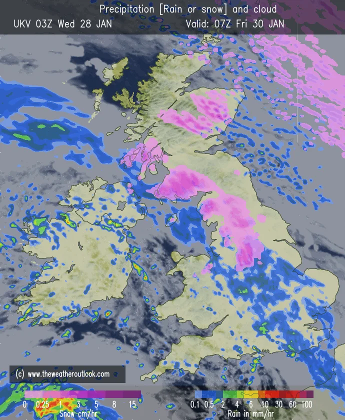
Friday will be another generally unsettled day, mostly cloudy over the region. Rain will slowly spread northeastward through the morning as it tapers off overnight; some sleet or wet snow will briefly occur on the highest tops before turning back to rain. Light rain and drizzle will persist during the afternoon, with additional outbreaks, especially over highland regions where low cloud and mist are likely to persist much of the day. Temperatures start to get a bit cooler overnight as Atlantic air continues to dominate, but winds keep staying breezy. The morning may start rather cold and moist, particularly on roads and pavements which will be wet after the rain overnight. Precipitation should gradually become more sporadic and increase the amount of dry spells in some areas as the day continues. The thick cloud will not allow for much development of sunshine, however. Fog can persist on higher ground for several hours, making it difficult for people to see over it when walking or driving on exposed roadways. The later arriving milder air should ensure that widespread frosts do not occur, but sheltered areas may be cold in the early morning.
Weekend Overview
The weekend is still rather unsettled with temperatures remaining relatively mild for the end of January. There will still be plenty of cloud, but occasionally brighter spells will return – particularly on Saturday. Most areas will receive fairly light rainfall, with heavier showers likely in eastern and higher parts of the area on Sunday. Overall, very few signs of any major change, with the weather systems coming from the Atlantic still having a big influence. Unfortunately, the weekend will continue to be dull, with not much longer sunshine in sight, but the relatively mild temperatures will make it less harsh. Short breaks in the cloud could provide useful opportunities for outdoor activities, especially during the daytime. However, if walking or an excursion is arranged within a specific area, it is advisable to prepare for potential abrupt changes even if thicker cloud is present, as a shower may develop rapidly beneath it. There will also be a high likelihood of wet ground after a series of wet spells, especially in parks, fields and countryside paths.
Saturday
Saturday has mixed weather with some distinct local variation throughout the region. The conditions will be overcast in many places for the bulk of the day, with some areas seeing drizzle or light rainfall. But a few areas, especially towards the west of the area, may get some gaps in the cloud for bright or even sunny spells at times. Even though the sunshine will be light, late January is going to be milder than the past few days have been. In all, it will be a pretty average winter’s day most of the time that you are outside. It will probably happen during lighter breaks, when there will be less turbulence and warmer weather that will make it easier to stay outside. Clouds may thicken up again in the evening, and there will be further drizzle in places. Upper parts of Oldham may be cooler and misty than lower parts of the area, and visibility may be reduced at times.
Sunday
Heavy outbreaks of rain are also likely on Sunday, mainly inland and on the higher ground to the east, and it is mostly cloudy. Western areas might experience a brief spell of cloud breaks, but most of the area will stay mostly cloudy. Winds, however, will be lighter than earlier in the week, with some of the rain becoming moderate or locally heavy during the afternoon. Temperatures are still quite similar to the season, so any wintry weather stays in the highest peaks. The heavier showers will only be of short duration and not cause the area to receive prolonged rain. The situation will be more tranquil by evening, but with a high degree of cloud. Temperatures may drop sufficiently during that break in the clouds for isolated frost to occur in sheltered spots, such as where surfaces are still wet, overnight.
Outlook
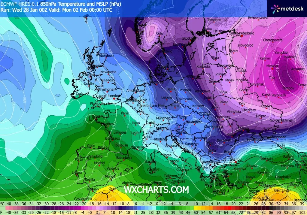
As it moves into early February, the overall Oldham Weather Forecast is little different. Weather Forecast systems from the Atlantic will persist, with more cloud and occasional rain and windy weather. Across the northeast of Europe, high pressure will continue to weaken these weather systems as they progress across the UK, so the heaviest rainfall will remain; however, across Oldham, the highest cloud will be more persistent rather than heavy downpours. We still have no evidence for a major cold outbreak to form during the first week of February from forecast models. Weather will be relatively stable, with temperatures around or slightly above normal for the season, and overnight frosts will be limited as a result of the widespread cloud cover. Where there is snow, it is likely to be short-lived and will mostly be sleet or wet snow, over the Pennines and other high areas. Many people are hoping for a proper winter cold spell, but the signs that we are seeing at this time suggest they will have to wait.
Rather, those in the areas can look forward to more of the same familiar weather pattern: overcast skies, wet and windy weather periodically, and only partial sunshine. Confidence in the forecast could slowly drop through the month of February with a possible change in pressure patterns over northern Europe. Longer-range forecasts are best taken with a pinch of salt as a change in wind direction could quickly reverse the trend in temperatures around northern England. As of this time, there is little evidence of a prolonged severe winter event, and there continues to be a lot of changeable Atlantic weather. Residents should keep monitoring the latest forecasts before travelling or planning, especially when travelling across the Pennines or other exposed areas. Lower-level colder air would first be felt along higher terrain where wintry showers may increase in frequency before lower levels.