
Oldham Weather Forecast: Windy, Damp Conditions Continue as Colder Air Gradually Arrives (22nd–25th January 2026)

The latest Oldham Weather Forecast shows another spell of unsettled winter weather, with plenty of cloud, occasional rain and brisk winds dominating the coming days. While many people continue hoping for a significant cold snap, current weather models suggest that any colder air arriving next week is unlikely to develop into a major winter event. Instead, the forecast points towards gradually falling temperatures, plenty of overcast skies and only a small chance of wintry weather over higher ground. For several weeks, the weather across northwest England has been controlled by Atlantic weather systems moving across the country. These systems have brought repeated outbreaks of rain, extensive cloud cover and strong winds, while preventing colder continental air from spreading westwards. Although colder air remains close to eastern Europe, it continues to stay just beyond our reach, leaving Oldham with fairly typical late-January weather rather than prolonged frost or snowfall. As we move towards the weekend, winds will slowly turn more easterly, allowing temperatures to ease down by a few degrees. However, the lack of sunshine combined with persistent cloud and brisk winds will make it feel colder than the thermometer suggests. Any snowfall is expected to remain confined to the highest hills if it develops at all, while lower elevations are likely to experience drizzle or light rain instead. Although the forecast does become more uncertain during the second half of next week, there are currently no strong signals pointing towards a widespread cold spell. Instead, residents should prepare for another period of changeable winter weather with only gradual changes in temperature.
Oldham Weather Forecast Highlights
|
Day |
Weather |
Maximum |
Minimum |
Wind Gusts |
|---|---|---|---|---|
|
Thursday |
Rain and windy |
9°C |
5°C |
25 mph |
|
Friday |
Mostly cloudy with drizzle |
8°C |
4°C |
25 mph |
|
Saturday |
Cloudy and colder |
7°C |
3°C |
20 mph |
|
Sunday |
Cold, cloudy with patchy drizzle |
5°C |
1°C |
20 mph |
Thursday Oldham Weather Forecast
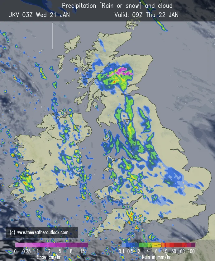
Thursday is yet another grey and wet winter’s day with rain also spreading north through Oldham during the morning and at isolated times for the rest of the day. Temperatures will still be above normal for the time of year, but will be further chilled by the fresh southeasterly wind. The weather will be cold due to the dampness, wind and cloudiness. Rain will become lighter during the evening and will clear overnight, but there will be a windy period Friday morning.
Friday Oldham Weather Forecast
Friday is a little better than Thursday, which was wet, but with still limited sunshine. The primary region of rainfall would have shifted to the north and another region of low pressure would have lingered well to the south west of the UK. Oldham is nestled between these weather systems and so will be another mostly cloudy day, with only occasional drizzles and light rain. Mostly, winds will continue to be strong during the day with outside temperatures staying near average for late January.
Weekend Weather Forecast Overview
Colder air is slowly filtering in across the weekend with winds more easterly to northwest England. Although rainfall amounts should remain fairly limited, extensive cloud cover will continue to dominate the forecast. There will be a chilly bite to the air with frequent drizzle and gloomy skies, but temperatures will only drop slightly. Sunnier weather can only be expected to be short-lived as cloud is the main feature all weekend.
Saturday
As the airflow turns to the E or NE, temperatures will slowly fall on Saturday. Thick cloud is forecast to dominate the North Sea region, with some drizzle patches at times. The day should be generally light in rain, but the clouds and cool breeze will make it seem much chillier than the other days. It will be a very limited amount of sunshine, with a few brighter spells not ruled out in the afternoon.
Sunday
Sunday will be a similarly cold day with a high proportion of cloud, and some drizzle and mist on higher ground. Winds will slightly ease from the previous week; however, with less sunshine and colder air, a definite winter feel will remain. If skies clear overnight, a patchy frost could develop in some locations, particularly in sheltered areas. Overall, it will be cold, grey and not really wet, but fairly damp on Sunday.
Additional Weather Details
There may be a greater difference in temperatures between lower parts of Oldham and the higher ground to the east of the town as the colder air flows around the region. Cloudier and possibly higher winds compared to more sheltered areas for longer at higher locations. There may also be mist or drizzle at times over the hillier routes, especially when moist air comes in from the North Sea. It is likely to be the most miserable of the forecast period on Thursday with the rain, wind and thick cloud all adding to the winter gloom. Surfaces such as pavements and roads will be likely to be wet even if it gets lighter later in the day. It is therefore recommended that drivers allow longer travel times, and take into account the potential for spray and diminished visibility.
Friday will be a bit less wet, but with no sun it might seem nothing special. Daytime hours can feel darker when it’s cloudy, because it can be more like nighttime. Cloudy days can make it feel a lot darker, especially early in the day and late in the afternoon. Any individual going out for work, school, or shopping should still be prepared to have waterproof clothing, as sometimes it will drizzle without warning. The weekend may also see variations between shaded and exposed locations. Exposed roads and open spaces could have a noticeable easterly breeze, while sheltered areas of Oldham may remain relatively calm. Warm layers will still be effective as the wind chill can make temperatures seem several degrees colder than they really are.
Outlook
There is little immediate change in view as we head into the new school week according to the Oldham Weather Forecast. Monday and Tuesday will be cold, mostly cloudy and generally dry with isolated areas of drizzle where cloud is thick. The temperatures should be similar to Sunday’s, with strong winds keeping them colder than what they read. Next week is a week of decreasing confidence as weather models are split on the location of high and low pressure areas. If colder air from eastern Europe can get much further west, then it could drop another 2 or 3 degrees, bringing the risk of snow showers over the Pennines and other high areas. But the latest projections indicate that this is not yet a reality. Also, there’s the possibility of milder Atlantic air again coming back before the end of next week, in place of the colder easterly winds. Residents should have a feeling of cooler weather gradually coming in but not an extreme outbreak of winter weather, and for the most part, expect cloud to be the main weather story in the forecast.