Oldham Weather Forecast: Brief Cold Snap Brings Hill Snow Before Brighter Weather Returns (12th–15th February 2026)
The next Oldham Weather Forecast indicates a completely new pattern after some truly grey, wet and lifeless weather. So far this year, February has been quite grey with plenty of cloud and a few showers. So far it’s not been particularly hot and humid, but it has been very overcast, so January has been much cooler than some of us would have loved. Fortunately, there are definite indications that this moribund stuck-in-a-rut weather situation is beginning to give way. A cold northerly will move in over the next few days, resulting in more of a winter feel for this time of year. This will bring the colder weather, the possibility of hill/snow, a hope for mostly filling nights with frost, at least one day of much-needed sunshine, and then some Atlantic weather systems will return again next week. I don’t think this is going to be a freezing cold stretch, but it should be a reminder that only soon might it be time to wave goodbye to winter. People traveling over higher elevations need to be aware of the shifting weather for Thursday night and early Friday morning, as snow is indeed a possibility over the higher elevations. All in all, this Oldham Weather Forecast combines some colder air, brighter skies, overnight frosts and a likely move to milder conditions but still wet towards next week.
Oldham Weather Forecast Highlights
|
Day |
Weather |
Maximum |
Minimum |
Wind Gusts |
|---|---|---|---|---|
|
Thursday |
Cloudy with rain, turning colder with hill snow overnight |
5°C |
0°C |
20 mph |
|
Friday |
Early wintry showers then bright and cold |
4°C |
-3°C |
20 mph |
|
Saturday |
Frosty start followed by sunshine |
4°C |
0°C |
15 mph |
|
Sunday |
Wet and windy, becoming milder later |
6°C |
4°C |
35 mph |
Thursday Oldham Weather Forecast
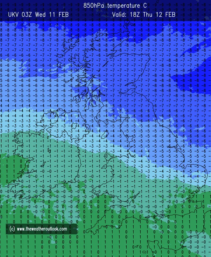
On Thursday, there is a rather significant pattern change in our weather expected to begin. Colder air will gradually flow across this area as after-mild conditions are replaced by northeasterly winds throughout the day. It is expected to be mostly cloudy with some light rain/drizzle in places in the morning before this slowly clears for a while. A few brighter spells could occur in the afternoon, though much of Oldham will remain over thick cloud throughout much of the day. During the evening, when temperatures continue to fall, higher elevations become of interest, and rain will turn to snow more frequently. Some further light cover is likely across the Pennines and other upland areas overnight, and up to a few centimetres will occur on the highest roads at least. Also, lower-level areas can briefly experience some sleet or wet snow – certainly not a significant depth at these altitudes. Anyone driving on un-enclosed roads should be extra vigilant as the low temperatures approach freezing. As well as the damp and wet roads, plummeting temperatures also have the potential to create slippery spots in some places before Friday morning, so it would be wise to take a bit of extra time for any early drive.
Friday Oldham Weather Forecast
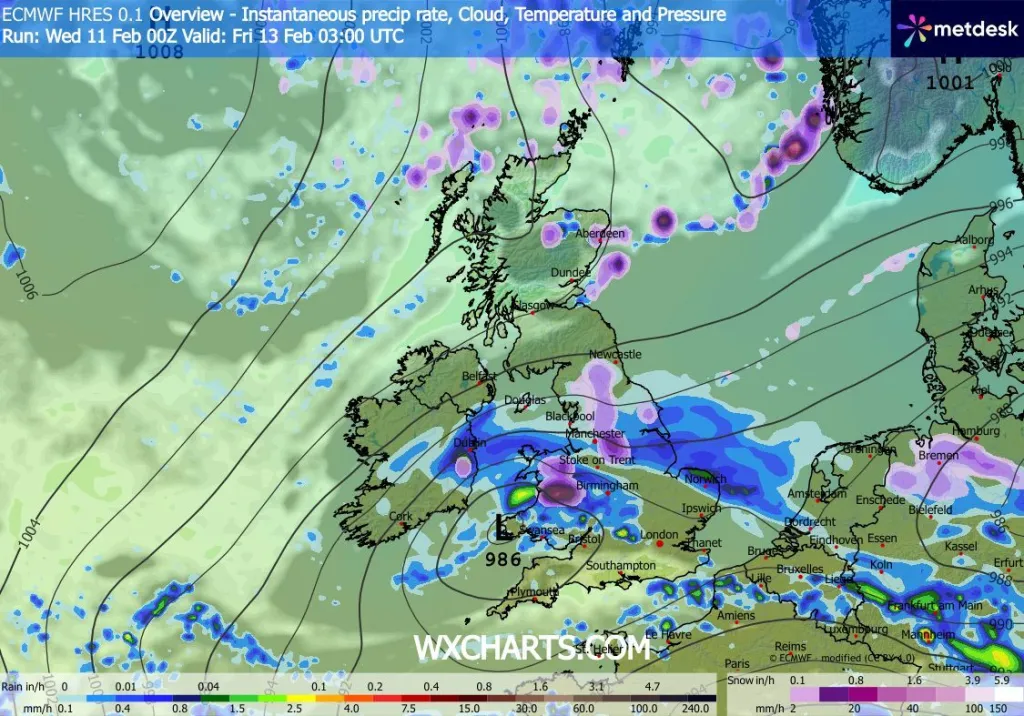
Friday begins with a chance for some lingering light rain, sleet or hill snow early in the day, particularly up high. Eventually, as the morning progresses, this wintry downpour will clear to the south, with a brighter morning over the rest of the area. As daytime progresses, sunshine will increase in amount, but still well below recent temperatures due to the colder northerly flow. When the sun does shine, it won’t be your nice warm sun to warm up with, especially in light of the breeze. However, for many people, after what seemed like endless cloudiness in recent weeks, the return of blue skies and much better visibility in the future can only be welcomed. Skies will become increasingly clear during Friday evening and overnight. Combined with lighter winds, this clear sky will help temperatures to plummet further, allowing many areas to be expected to experience widespread frost by morning. They may be wet in the first few spots where it has not yet frozen, and in the following areas ice formation could occur before Saturday. People leaving the house early should be aware of the potential for this ice to lie on untreated or ice-covered roads and on pavements, so they need to take some extra precautions underfoot and behind the wheel. During this section of the Oldham Weather Forecast, you will see one of the longest and happiest days of the year for many people, despite being one of the coldest segments of the outlook.
Weekend Overview
Weather gets a lot better on the weekend, as Saturday looks to be the nicest of the forecast period with Sunday continuing to be unsettled. Even though the cold is hanging in for Saturday, let’s hope for a much nicer day than the past few days with a crisp beginning, more sunny and lighter winds! But this lull will be short-lived with cloud thickening later in the day in advance of the next Atlantic weather system. Rain will return by Sunday as well as higher wind speeds, whilst milder air gradually takes over from the colder northerly flow earlier this week. Overall, this part of the forecast is a big change between the two days of the weekend, from crisp and bright to wet and breezy in just a day.
Saturday
The highlight of this Oldham Weather Forecast is Saturday. Following a broad thaw in the early morning, people will be in for lots of sunshine, blue skies and superb night sky visibility in most areas of the country. We’ll have northerly air, which will mean temperatures will be lower, but lighter than we’ve had on the previous days, so that sunshine should really make it feel more comfortable for anybody spending time out on the streets. Cloud will slowly start to come in from the west later in the afternoon, and this will start to decrease the amount of sunshine that can be had. Despite this, the majority of the daylight is forecast to be dry and more truly refreshing. Cloud will thicken again in the evening and overnight as the next weather system approaches from the Atlantic Ocean. Rain will extend into this area tonight with possible short outbreaks of snow over the Pennines and other higher tops, which will then be transformed back to plain rain by the quick arrival of milder air. Saturday will by far be the brightest and most settled day of the whole forecast period: that’s the one to put first on the list of days for anyone planning something outdoors.
Sunday
A change in the weather is to come to northwest England on Sunday with the Atlantic systems asserting themselves again. During early morning hours, it will begin to rain with building southwesterly winds increasing during the day. It will be a short time until this additional snow continues as rain when it falls higher than the ground overnight, as milder air moves its way into the area. Dirty, dusty, windy, and with fairly persistent rain for a number of hours in the morning. The steady rain should slowly ease and scatter throughout the afternoon, allowing brighter intervals between the intermittent rain. Through the day, temperatures will be a little better than many feared for Friday and Saturday, but with a benign airflow now calling the shots. Nevertheless, it is still going to feel jittery and irritable underfoot and overhead, with the seething winds stronger in more exposed areas over the borough. Roadways will be wet on Sunday days and you should expect the wind to be higher on the higher/rider open routes, so be prepared.
Outlook
So, out of the weekend, according to this Oldham Weather Forecast, this quick chilly turn will soon be a thing of the past. Expect more Atlantic weather systems as they intensify by the end of the week and start sweeping from the west to east along the country. These systems should push on through faster than the slow-moving weather pattern we have had recently, with the hope of brightening up the gaps and spells of wet weather. Temperatures will rebound back towards average levels this week, and may bring in a slightly cooler feel towards the end. There are still clouds of sunshine to come, but brighter spells will be emerging in between the current fronts of each day. Overall, next week will be very much a typical mid-February with plenty of rain and cloud, a few days of sunshine and some breezy periods, with none or just a handful of consecutive days having one single weather theme as can happen in recent weeks – dubbed a ‘grey Feb’ and hopefully a breath of fresh air after that grey February week which just ended.
Weather Tips
| Tip | Advice |
|---|---|
| Wrap Up Warm | Cold northerly winds and overnight frosts will make it feel much colder than recent days. |
| Drive Carefully | Hill routes may become slippery where snow, frost or ice develops. |
| Enjoy Saturday | Saturday is expected to provide the best opportunity for outdoor plans with sunshine and lighter winds. |
| Carry Waterproofs | Rain and stronger winds return on Sunday, so waterproof clothing will be useful. |
| Check Hill Conditions | If travelling across higher ground, monitor local weather updates for any snow-related disruption. |