Oldham Weather Forecast: Winter Draws to a Close, but Colder Weather Still Lurks Ahead (26 February – 1 March 2026)
This is this week’s Oldham Weather Forecast. As the snowy winter season comes to an end, and the sunny spring season is fast approaching, many people are anticipating more sun, clearer skies and softer temperatures. While this winter has not ended up with much snow in northwest England, it has had a fair amount of cold days, thick cloud, and plenty of grey skies in total. There have been far fewer sunny spells, and although totals of rainfall have been below average for most of the year, the days have certainly been damp in many places due to the high frequency of cloud and light drizzle. The prediction for the next seven days is similar, as the next few days are supposed to be windy and unpleasantly cold, before clearing up next week. There will be showers in both Thursday and Friday, with Saturday looking significantly brighter as there is a spell of welcome sunshine, but another rain band is set to hit the opening day of meteorological spring. Further out on the weekend, there are some encouraging signs that the high pressure may get the upper hand, allowing for the dry and sunny conditions that were brought by the high last weekend to return. As spring is getting underway, it’s back to remembering that colder weather is not far off this time of year, says this Oldham Weather Forecast, so everyone should have to bear in mind that the weather is changing from day to day.
Oldham Weather Forecast at a Glance
|
Day |
Conditions |
High |
Low |
Wind |
|---|---|---|---|---|
|
Thursday |
Cloudy with heavy rain |
11°C |
8°C |
Up to 30 mph |
|
Friday |
Patchy rain, turning colder |
11°C |
2°C |
Up to 20 mph |
|
Saturday |
Sunny spells, dry |
8°C |
5°C |
Up to 20 mph |
|
Sunday |
Cloudy with periods of rain |
11°C |
7°C |
Up to 30 mph |
Weather Highlights
Thursday Oldham Weather Forecast
April’s first day out will be relatively quiet as cloud will dominate most areas over Oldham, though it will be kept dry for much of the early morning for those getting up regularly for work or school. The cloud will become thicker and come in from the west as the hours go by, which means that an approaching system off the Atlantic is approaching. Outbreaks of rain extend a broader reach later into the morning and into the afternoon, where it may be quite hefty in some areas and lingering for several hours at a time for many, once this system arrives. The SW wind will also increase in strength during the afternoon, bringing a more breezy component as well; especially in the more open and exposed areas of the borough where the gusts will be more pronounced. Despite all this unsettled weather, temperatures will stay on the sidelines quite reasonably for late February, with highs reaching around 11°C in the afternoon and dropping back down again in the evening. In particular, drivers should make some allowances for journeys as the heavier downpour could cause standing water when the roads are wet, as well as loss of visibility, which may catch people out if they aren’t expecting it. The day with the most rain came on Thursday according to this Oldham Weather Forecast, and this was the worst of the four days for anyone planning to spend time outdoors.
Friday Oldham Weather Forecast
Friday will be cloudy with some individuals of light and patchy rain moving through areas during the day. This rain, unlike the previous day, should be much lighter and intermittent, but the overcastness will help keep things rather dull and flat for most of the day. Today will be similar to Thursday with afternoons around 11°C, but if the weather is anything like Thursday, then the main event of today will be the slow return of the wind towards the northwest as the rain-bearing front passes. This brings in a much colder air mass for the evening in a definite tumble, with skies clearing and air becoming decidedly colder after dark. There were some less exposed areas where some frost may develop later into the night, bringing temperatures down to mid-2C by the early hours of Saturday morning. Friday too should be largely unremarkable, but it does represent the waning of the wet, mild, and at the same time relatively dry, weather and the start of cooler weather ahead for the weekend. Friday night would be a good time to keep an umbrella and an extra layer, spooky cool as it’s set to drop quickly after the sun sets, compared to recent nights, when it has only fallen slowly.
Weekend Weather Outlook
Saturday
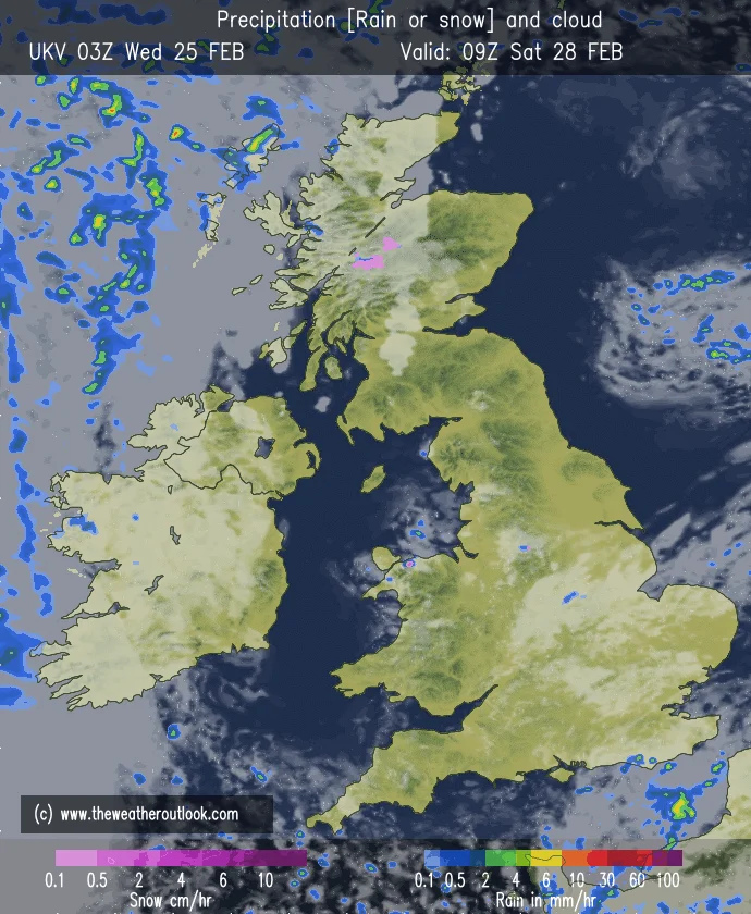
Fresh colder air will sweep in behind Friday’s weather front, with Saturday slated to be the highlight of the weekend. The weather may start out cold, with some frost in more sheltered north-facing places throughout the day, but the sunshine will gradually increase throughout the morning in Oldham. Lighter, more blue skies will be accompanied by a welcome drop in temperatures, especially in the afternoon, when highs will only reach about 8°C – but should be more comfortable than the previous few days were. As the afternoon progresses, some of the higher, thinner cloud will drift in off the west, giving the sunshine a slightly hazy or milky appearance as opposed to blue skies on a sunny morning. Despite this additional cloud drifting in, the day should leave dry for just about everyone, with any risk of rain delaying until after dark falls. Winds will also give a bit of relief from the busier times of the previous days, with it being so pleasant to be outdoors, whether that’s for a stroll, some shopping or simply enjoying an early slice of spring sunshine. Saturday will be the best day of the week to have dry weather, but then there will be unsettlement after, says this Oldham Weather Forecast.
Sunday
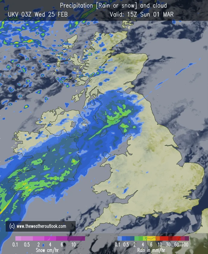
Meteorological spring on the opening day is likely to have far more severe weather. A slight degree less confidence in weather for the earlier days vs. this day because there is less certainty on exactly where a rain band will travel as it comes through. At present, the models suggest the rain will maintain its general direction, and at present this will be a cloudy and wet day with spells of rain, including a few moments of moderate or heavy rain. There will be a south-westerly wind returning to a similar strength too, in the form of gusts around 30 mph, making it rather blustery on top of the wet weather. Temperatures will be rising by about 11°C, but with thick cloud and persistent rain this won’t be felt as high as the temperature. If the band of rain moves slightly to the northwest from numerous models, it would be a drier-than-forecast scenario, but for now the wetter scenario is more likely. Anyone going outside this Sunday should bring waterproof clothing along, advises this Oldham Weather Forecast.
Temperature and Rainfall Outlook
This is the latest Oldham Weather Forecast with temperatures remaining fairly consistent with what we can expect during this time of year in the last days of February and first days of March. Afternoon temperatures will be in the high eighties/low nineties, dropping to 2°C to 8°C for the overnight lows, with a localised frost likely once the night comes to an end following Friday’s front. The rains will be mainly concentrated on Thursday and Sunday, while on Friday there will be lighter and more scattered thunderstorms that will come and go. The rest of the day, on Saturday, will be the driest, with cloud thickening for the remainder of the day after several hours of sunshine. Despite the continued fluid nature of the pattern, there is no sign of any extended cold period or significant snowfall for Oldham during this particular time-frame.
Outdoor Conditions
For those who are planning to enjoy outdoor activities in the coming days, the right timing will be crucial. Thursday and Sunday are the worst of the four days as it can rain and can be gale force, especially with the heavier rain showers and lower visibility that can result. Friday will continue to be cool and mostly cloudy with the rain easing and becoming soaker-free towards the evening. By contrast, it looks like Saturday will be the day for those who want to be outside as there’s no lack of sunshine and calmer winds, coupled with dry conditions throughout, and rain won’t feature until late in the day. Those who have gardening plans, have a stroll to plan or even family plans should make the best of the day on Saturday before the gloomier weather returns for Sunday. The Oldham Weather Forecast also gives a heads up to motorists who could be in danger of a speedy slide due to rain on both Thursday afternoon and on Sunday – have extra care when rain will be heavier at times.
Looking Ahead
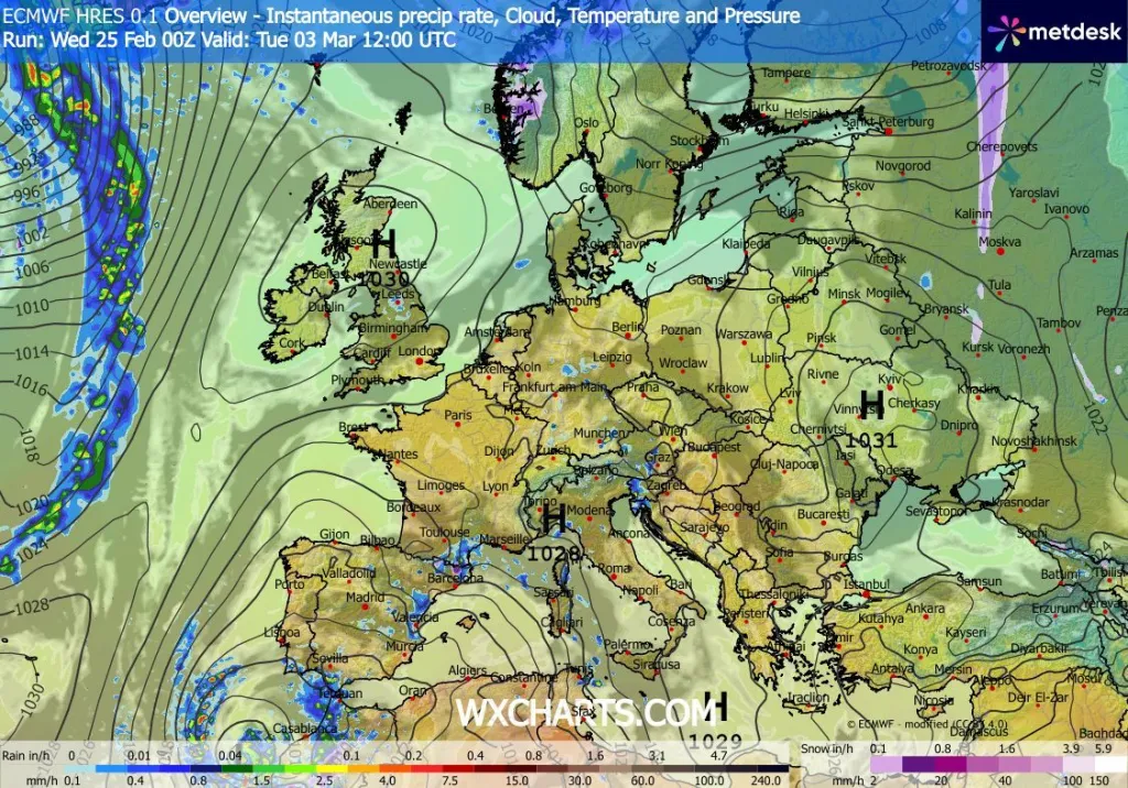
As it heads into the first full week of March, encouraging signs are emerging that the weather may be more settled. If there is any rain that persists into Monday, then it should ease eastwards, allowing brighter sunshine in the afternoon. Milder weather will return as well as some locations where sunshine prevails, reaching the low teens once again. Forecast models also suggest a possibility of an area of high pressure strengthening over the UK later on Tuesday, and providing several dry days with sunshine and milder winds. This trend is likely to reduce over time but will probably keep Atlantic weather systems further away, offsetting the increase in uncertainty as the forecast window expands. The Oldham Weather Forecast will be keeping a close eye on these changes and making further announcements as the confidence in this increases.
Forecast Summary
Overall, it has been a week that has been dominated by weather changing from meteorological winter to spring with a whiff of rain, a sprinkle of sunshine and a swing of the temperature. The heaviest precipitation occurs on Thursday, before the air cools appreciably on Friday with the return of the colder air for the first few hours of the day. The other days weren’t very noteworthy in terms of sunshine – the best and least soggy of the week is on offer this Saturday, at least some good sunshine, before the unsettled flags are lifted on Sunday as another decent bank of rain is due across the part. Looking further forward, things are looking better with high pressure expected to rise in strength, bringing a longer stretch of dry, brighter conditions later in the first week of March. Ah, Spring, the joys await, but this Oldham Weather Forecast is a warning that there could always be late cold snaps this time of year, so keep yourself prepared for the variability and take advantage of any sunny patches that appear.